Search

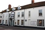
The Bear Hotel by Greene King Inns 
Charnham St, Hungerford, RG17 0EL
Show on map 0.27 miles from Hungerford
Hungerford, located in Berkshire, is situated on the River Dun near the Kennet Valley. The nearby area has been designated as an Area of Outstanding Natural Beauty. The highest point in the southern area is located nearby, Walbury Hill, located only 7 kilometers from the town. There are plenty of shops located in the immediate area as well as dining opportunities. In addition, there are numerous accommodation options located in Hungerford and in the surrounding area. The town is also easy to reach from other towns within the local area, via the M4 as well as the A4.
The English market town of Hungerford is located in the county of Berkshire. The town of Hungerford is also a civil parish. The town of Hungerford is located about ten miles west of Newbury. The town of Hungerford covers an area of about five thousand three hundred and seventy two acres. The town of Hungerford has a population of about six thousand seven hundred and eighty nine.
The town of Hungerford is located on the banks of the River Dun within the Kennet Valley. The town of Hungerford is the most western town within the county Berkshire and it is located on the Wiltshire border. The town is the highest point within the whole of England and the summit of the Walbury Hill is located about two hundred and ninety seven metres above sea level and it is about four miles from the town.
The town of Hungerford marks the border between South West England and South East England. The town of Hungerford is located about sixty eight miles to the western side of London and it is also about fifty-five miles to the eastern side of Bristol.
The town of Hungerford has a very strong transport network and these are a combination of both current and historic importance.
We hope you enjoy your stay in one of our cheap Hungerford hotels, mid range or luxury Hungerford hotels.