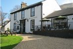
Rowantreebank Bed and Breakfast
Rowantreebank, Main Street, Arrochar, G83 7AA Show on map 0.38 miles from Arrochar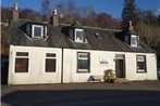
The Scottish village of Arrochar is located close to the top of the Loch known as Loch Long within the area that is known as Argyll and Bute. The village gets overlooked by a number of mountains, which together make up what is known as the Alps of Arrochar and the most distinctive part of these Alps is the summit of the mountain that is known as the Cobbler and the summit is rocky.
The village of Arrochar has a good communication network that comprises of the A814 and the A83 roads. The railway station that is known as Arrochar and Tarbet also serves the village. The road known as the A82 also serves the village, which is the main road from Tarbet.
For more than five centuries the chiefs of the clan that is known as MacFarlane has held the area that is known as the barony of Arrochar and prior to this it was held by their ancestors, which were known as the barons of Arrochar.
The western part of the village of Arrochar is the more traditional boundary of Dumbartonshire and Argyllshire. This traditional boundary was held until the reorganisation that took place in 1975. In 1996 it was decided that the boundaries between West Dumbartonshire and Argyll and Bute should be redrawn and this bring the whole of the Arrochar area into Argyll and Bute.
Arrochar was once a sure for torpedo testing however it got decommissioned during 1980 and it is at the moment partly demolished. During the testing the torpedoes got fired up Loch Long from the tubes that were located at the front of the testing facility. During the testing there was always a boat on stand by ready to recover the torpedoes that were unarmed and then they were returned to the facility for analysis.
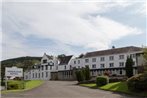
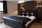
We hope you enjoy your stay in one of our cheap Arrochar hotels, mid range or luxury Arrochar hotels.